Footage of the flood on the border of Nepal and Tibet showed how a wall of water swept away villages, bridges and power plants

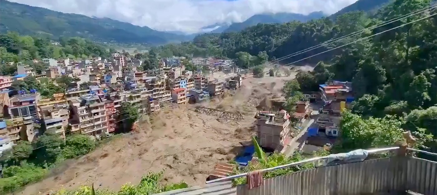
A massive flash flood tore through the Bhote Koshi riverbed in Nepal's Rasuwa district on the morning of August 26, wiping out villages, roads, and hydroelectric plants along the way. Authorities confirmed at least eight deaths, with 384 travelers still listed as missing. BBC put the total number of missing at around 400.
Nepal's Tourism Board said the preliminary list includes 291 foreigners and 93 Nepali citizens. Indians make up the largest foreign group with 105 people, alongside travelers from the US, Malaysia, the UK, Australia, and South Africa. The flood hit hardest in the villages of Timure and Syabrubesi, including the customs office building.
Early footage of the torrent sweeping away buildings spread across social media within hours, and some viewers assumed it was AI-generated. The clips have since been backed up by Xinhua reports, Chinese aerial photography, and images from the AP.
Rain wasn't the cause. Nepal Department of Hydrology and Meteorology noted that no heavy rainfall hit the Rasuwa area on either Tuesday or Wednesday. ICIMOD disaster risk reduction specialist Saslavata Sanyal said an ice and rock avalanche triggered the flood on the Lhende Khola river.
The mechanics here differ from a typical flood. Ice and rock debris slides into a narrow gorge and blocks the riverbed, water builds up behind this natural dam within hours, then the whole thing bursts at once. Kathmandu University professor Rijan Bhakta Kayastha added that a magnitude 4.4 earthquake struck the Tibetan side around the same time, 47 kilometers north of Gosaikunda.
Nepali researcher Mohan B. Chand said the avalanche originated on the Nepali side, and monitoring stations recorded water levels holding at seven meters. A second wave remains possible.
The wave moved quickly downstream along the Trishuli. By 10:51, the flood had reached Galchhi in Dhading district, with its arrival in Mugling expected within hours.
Authorities put five districts on high alert:
Rasuwa
Nuwakot
Dhading
Gorkha
Chitwan
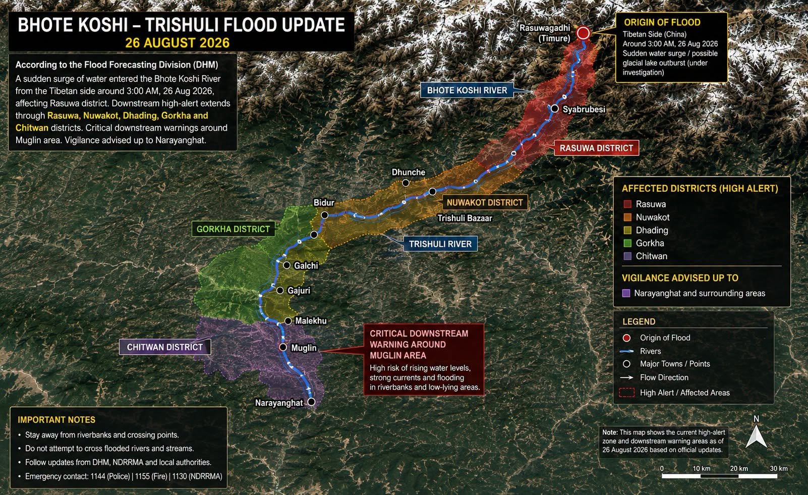
The Flood Forecasting Division ordered evacuations of riverside settlements and markets along the Trishuli, covering sections near the Prithvi Highway and the Mugling-Narayanghat road. The Cabinet declared the affected areas disaster zones and approved ten response measures. Search efforts now involve two army helicopters, along with the army, armed police, and Nepal Police.
On the Chinese side, the flow reached the Gyirong border port. The Gyirong County Emergency Management Bureau in Shigatse reported damaged roads leading to the crossing, along with cut communications and power outages. Drone footage showed parts of the port buried under debris from the flood.
CCTV reported at least 574 rescuers deployed to the area, though a meter and a half of sediment blocked access routes, turning what should be a short trip into a four-hour journey. Authorities sent 145 troops from the Shigatse detachment of the People's Armed Police to the site, and Xi Jinping ordered an all-out effort to find those still missing.
Nepal energy infrastructure took a serious hit. The Ministry of Energy estimated losses at 430 MW, more than 12% of the country's total hydropower generation of 3.2 GW. The affected plants include:
Rasuwagadhi hydropower plant, 111 MW
Sanjen Khola hydropower plant, 78 MW
Upper Trishuli 3A hydropower plant, 60 MW
Langtang Khola hydropower plant, 20 MW, where concrete work was underway in a tunnel
The WHO is sending medicine and equipment to the affected regions. India's Bihar state stepped up monitoring of the Gandak and Koshi rivers, which receive runoff from the Trishuli.
This isn't the first time this stretch of border has taken a hit. A flood on the Bhote Koshi a year earlier killed nine people and left 24 missing, and swept away the Friendship Bridge connecting Nepal and China. That disaster was traced back to a glacial lake outburst on the Tibetan side.